Hola mundo
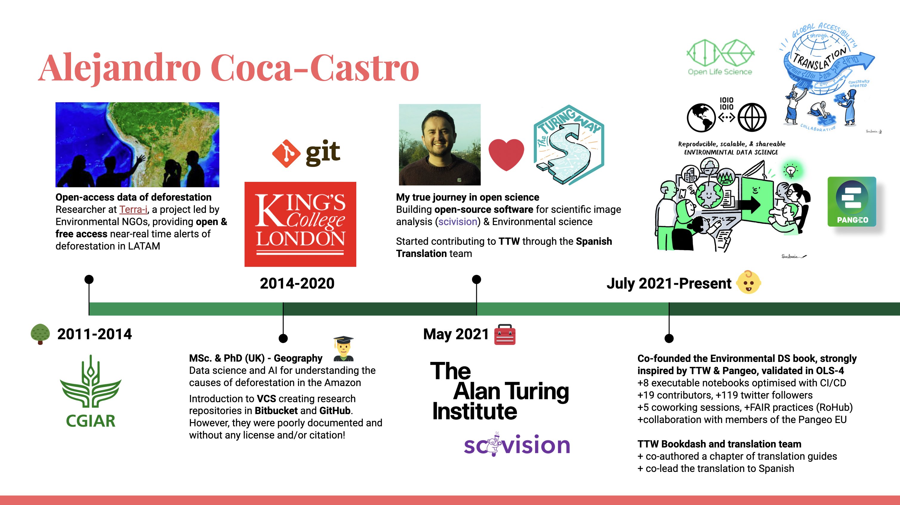
Motivado por la línea de tiempo con la cual participé en la reunión de fogón organizada por el Turing Way la primera entrada de mi blog es una reflexión de lo que ha sido mi recorrido en los últimos 11 años.
Contaré resumidamente mis experiencias más relevantes en la ciencia medioambiental abierta y tecnologías de la información mediante una serie de anécdotas por etapas. Dichas anécdotas van más allá de lo técnico e incluyen oportunidades que comparto para que sean aprovechadas por otros identificados con caminos similares.
¡Iniciemos!
Etapa 0 inicios, < 2011
Aunque no lo pude reflejar en mi línea de tiempo, desde mis estudios de pregrado en Ingeniería Agronómica obtuve mis primeros acercamientos en las tecnologías de la información espacial. Tuve la oportunidad de cursar materias relacionadas con modelos y datos espaciales como parte del programa de posgrado de Geomática en mi alma mater, la Universidad Nacional de Colombia. Igualmente, realicé un intercambio con la Universidad de São Paulo, Brasil, donde conocí una nueva cultura y participé en grupos de investigación usando las tecnologías de geoprocesamiento aplicadas para estudios del medio ambiente y agricultura. En este intercambio me entrené en varias herramientas de procesamiento de imágenes satelitales tanto de licencia cerrada entre ellas ERDAS y ENVI, y de licencia abierta como SPRING. Asimismo, mis conocimientos en SIG fueron principalmente en ArcGIS, y un poco en QGIS. Ya finalizando mis estudios, en el mes de Mayo de 2011 tuve la oportunidad de poner a prueba mis conocimientos con mi primera consultoría realizando una base de datos y cartografía para un catálogo de plantas medicinales en Colombia (ver detalles aquí).
Oportunidad 1 - Movilidad internacional
Etapa 1 datos abiertos de deforestación, 2011-2014
Como parte de mi práctica profesional del pregrado ingresé al proyecto Terra-i en el Centro Internacional de Agricultura Tropical (CIAT), ahora conocido como la Alianza Bioversity-CIAT. Este proyecto tuvo un impacto muy positivo en mi desarrollo profesional. Terra-i es una iniciativa para el monitoreo global de la pérdida del hábitat generando alertas de deforestación de manera gratuita y abierta. Debido a la relevancia del proyecto con la agenda de la organización, participé en varios subproyectos que usaban los datos de la herramienta para cuantificar el estado de los ecosistemas en Latinoamérica y Caribe así como para pronosticar el impacto de proyectos de infraestructura vial en la región (ver detalles aquí).
Como investigador proactivo representé el proyecto en varios eventos internacionales en temas de conservación, bosques y tecnologías geoespaciales. Asimismo, promoví extensivamente el uso de los datos abiertos a través de estudios de caso en el blog del proyecto (ver por ejemplo). Fui autor y coordinador de un protocolo para la validación en campo de las alertas de deforestación en el Amazonas peruano el cual posteriormente fue replicado en otras regiones. En términos de comunidades, fui becario de la Sociedad para la Conservación SIG (SCGIS), un programa financiado por ESRI y organizaciones ambientales, que personalmente recomiendo para mejorar conocimientos en herramientas SIG y conocer otros investigadores a nivel mundial aplicando estas tecnologías para la conservación.
Oportunidad 2 - Programas de entrenamiento en SIG
Etapa 2 MSc. y PhD en Geografía, 2014-2020
Como parte del proyecto Terra-i, conocí a Mark Mulligan, profesor de King’s College London con quien en colaboración con el proyecto Terra-i abordamos el estudio de las causas de deforestación en el bioma amazónico. Fue un periodo donde me capacité y apliqué la ciencia de datos, inteligencia artificial y computación en la nube. De esta manera, en mi maestría analicé los patrones espaciales de la deforestación mediante el uso de minería de datos y análisis fractal (ver detalles aquí). A partir del uso de dos fuentes de datos abiertos de deforestación, Terra-i y los mapas de Global Forest Change, mi investigación logró mapear la distribución espacial de patrones espaciales asociados con diferentes agentes de deforestación. En el doctorado tuve un abordaje más profundo con la aplicación de técnicas de análisis de las series de tiempo para extraer información de las coberturas y uso posterior a la deforestación a partir de imágenes satelitales (ver detalles aquí). En esta investigación se innovó en el uso de redes neuronales recurrentes convolucionales para la clasificación de series de tiempo de imágenes MODIS. Los modelos fueron entrenados usando recursos hardware del proyecto Terra-i así como créditos de computación de la nube de Google.
Más allá de los avances técnicos durante mis estudios, pienso que lo más emocionante fue maximizar la colaboración y movilidad (intercambios, pasantías, conferencias y grupos de investigación). Por ejemplo, en mi maestría hice un intercambio en Global Canopy, una ONG ambiental con sede en Oxford, Reino Unido en la cual hice un análisis de la seguridad hídrica en el Amazonas (ver detalles aquí). En el doctorado, hice intercambios en el año 2011 en HEIG-VD en Suiza y posteriormente en 2019 en la sede regional en Asia de CIAT en Vietnam. En la primera institución recibí entrenamiento en programación en Python, Big Data y Deep Learning en el laboratorio liderado por el profesor Andres Perez-Uribe, y en el segundo perfeccioné los análisis y modelos con mi co-supervisor en CIAT, Dr Louis Reymondin. También quiero destacar la pasantía en el verano de 2018 realizada en Satellite Application Catapult en el campus de ciencia e innovación de Harwell (Reino Unido) donde participé en la aceleradora Frontier Development Lab (FDL). En esta aceleradora participé con otros investigadores afiliados en instituciones de Europa para el mapeo de asentamientos ilegales a partir de imágenes de resolución media como Sentinel 2 y muy alta como WorldView-4 (ver detalles aquí).
Oportunidad 3 - Créditos gratuitos de investigación para la computación de la nube de Google y Microsoft
Resumen
En esta primera entrega de Alejandro 101 resumidamente conté mis experiencias desde mi pregrado hasta el doctorado. Fueron diferentes personas que me inspiraron y pude colaborar durante todos estos años. Fue un periodo lleno de muchos logros profesionales y personales con unas amistades muy valiosas que aún conservo, así como la satisfacción de poder iniciar la familia Coca Calderón durante el tercer año del doctorado.
En la próxima entrega continuaré con la segunda parte de la línea de tiempo, a partir de la cual considero estoy construyendo satisfactoriamente nuevas bases para el liderazgo de la ciencia ambiental abierta. Igualmente, comentaré oportunidades y experiencias que pueden resultar interesantes!
Por una ciencia incluyente y transparente 🚀