Hola mundo
En la anterior entrega describí en mi trayectoria desde el pregrado a doctorado, la cual fue sin duda una etapa satisfactoria con bastante crecimiento personal y con innumerables logros académicos y profesionales. Para la segunda entrega compartiré lo vivido durante la pandemia, un periodo muy difícil para toda la humanidad, pero que nos recuerda lo frágiles que somos como cualquier otra especie viviente en la tierra.
¡Continuemos!
Etapa 3 Pandemia e incertidumbres
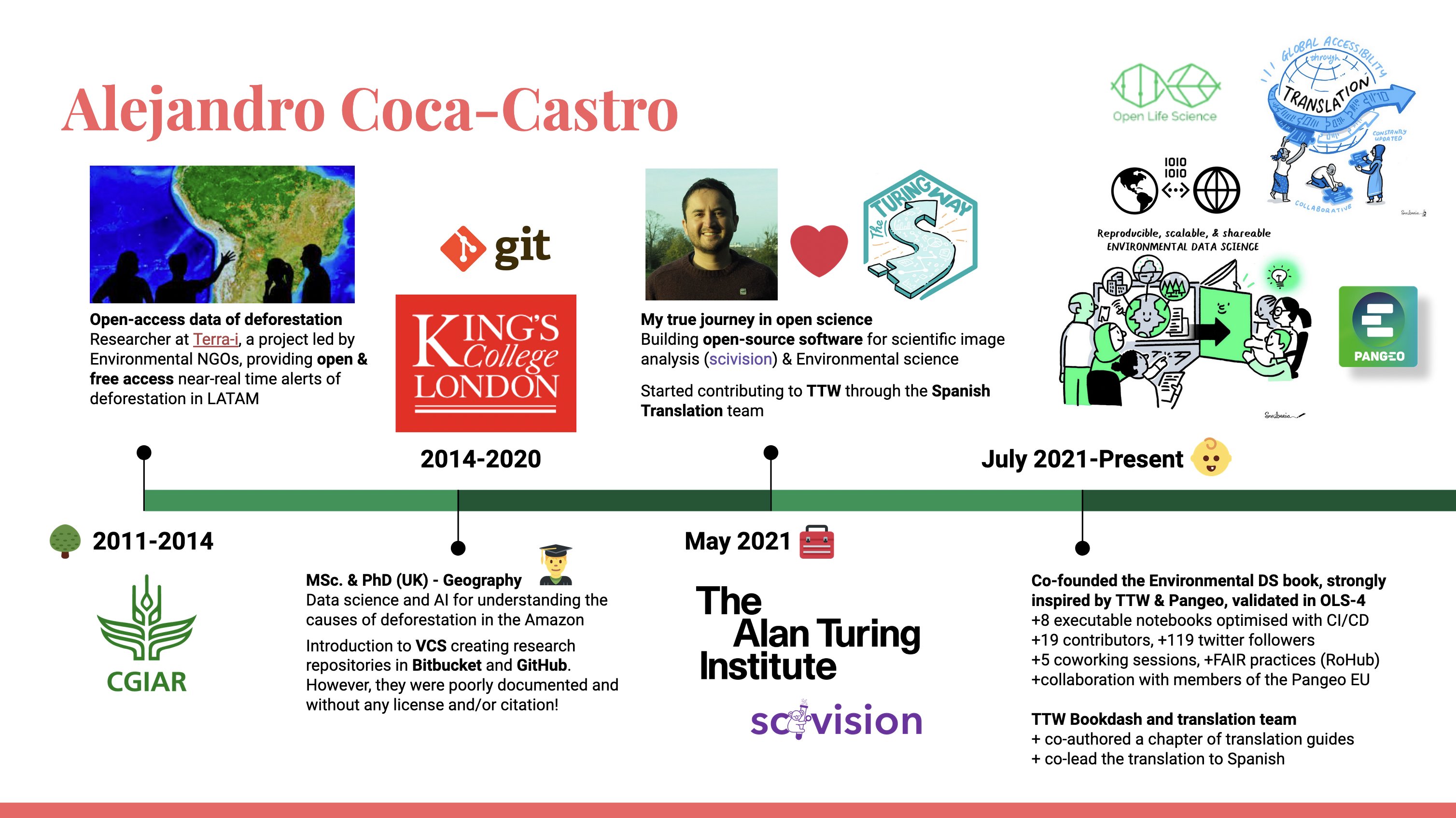
Comenzamos en marzo de 2020, cuando las restricciones por COVID-19 iniciaron en la mayoría de los países y coincidieron con el plazo límite para entregar mi tesis de doctorado. Aún más, era el mes de finalización de los fondos del crédito-beca otorgado por mi patrocinador. No teniendo muchas opciones, decidimos con mi esposa dejar Londres y regresar a Bogotá (mi ciudad natal). A pesar de todas las presiones posibles, cumplí con el propósito de enviar mi tesis el día 30 de marzo de 2020 ¡un día muy memorable! Posteriormente en mayo de 2020 defendí mi tesis de manera remota celebrando por videollamada con mi familia, supervisores y amigos. Luego recibí mi diploma de doctor de Geografía en King’s College London en septiembre de 2020.
Dentro del periodo de correcciones de mi tesis y búsqueda de opciones laborales fui seleccionado en un programa de capacitación virtual de ciencias de datos del gobierno de Colombia organizado por Correlation One. Como parte del programa, con otros participantes aplicamos lo aprendido en un proyecto enfocado al desarrollo de modelos y tablero de datos para predecir la reincidencia en el sistema penal colombiano (ver detalles aquí). Posteriormente en agosto de 2020, me vinculé como contratista del Instituto Geográfico Agustín Codazzi, una entidad del gobierno colombiano conocida por su rol en la cartografía y ordenamiento territorial. En mi contrato de 5 meses tuve la oportunidad de ser el líder técnico de grupos de 5 a 6 investigadores y publicar en revistas científicas resultados de dos proyectos relacionados con tecnologías de ciencias de datos e inteligencia artificial para el mapeo de construcciones en ámbitos rurales (ver detalles aquí) y el mapeo digital de suelos (ver detalles aquí). Asimismo, coordiné un reto del programa de ciencia de datos de Correlation One que buscaba desarrollar modelos predictivos a partir de una base de datos de suelos del IGAC (ver repositorio aquí).
Con la culminación de mi contrato en el IGAC y no teniendo mucho éxito en la búsqueda de opciones en la academia, decidí tomar el camino de emprender. En este camino cabe resaltar que fueron valiosos los aprendizajes que recibí en un programa extracurricular ofrecido por el instituto de emprendimiento de mi universidad durante el doctorado. De esta manera, registré GeoMagic Labs, una empresa consultora de tecnologías de la geolocalización, en la Cámara de Comercio de Bogotá. Con mi emprendimiento quedé seleccionado en un concurso de consultoría con Solidaridad Network, una ONG enfocada en facilitar el desarrollo de cadenas de suministro socialmente responsables, ecológicamente sólidas y rentables. En mi propuesta desarrollé una metodología para el mapeo de sistemas productivos de café usando imágenes satelitales de acceso abierto (ver detalles aquí).
Oportunidad 4 - Entrenamiento en Ciencias de Datos
Etapa 4 La ciencia abierta, Mayo 2021 - a la fecha
En noviembre de 2020 el reglamento de condonación del patrocinador de mi doctorado tuvo un cambio que abrió puertas a nuevas oportunidades. Ya no era obligatorio demostrar vinculación a una institución en Bogotá por el tiempo que recibí financiación (¡ósea 4 años!). El nuevo reglamento era flexible con otros tipos de productos incluyendo la publicación de artículos y/o iniciar un emprendimiento relacionado con el tema de doctorado. Bajo este nuevo panorama, apliqué a una plaza postdoctoral en el instituto de Alan Turing en Reino Unido en diciembre de 2020. Yo ya estaba familiarizado con el entorno del Turing por una anterior oportunidad de hackathon colaborativo que había participado en diciembre de 2019 (ver el reporte aquí). La plaza postdoctoral se ajustaba a mi perfil, y me llamó la atención la posibilidad de aprender de modelación probabilística, mejorar las habilidades en el desarrollo de software y contribuir a Pangeo, una comunidad que promulga la ciencia abierta para el análisis de grandes datos en la geociencia.
En el mes de febrero de 2021 recibí una comunicación para una entrevista la cual incluía una presentación de 5 min, seguido de una explicación de código de mi autoría y preguntas por parte del panel de la entrevista. Era mi primera entrevista de postdoctorado por lo que era natural tener un poco de nervios. No obstante, ofrecí respuestas acertadas resaltando mi experiencia colaborando en diversos grupos de investigación. En el momento de mostrar mi código logré demostrar cómo este había sido usado o visitado en Zenodo (una plataforma para registrar cualquier objeto digital de investigación). A las pocas semanas recibí la comunicación de oferta de la plaza iniciando remotamente desde mayo de 2021. Posteriormente, con mi esposa dejamos nuestra vida en Bogotá y decidimos reiniciar nuestra vida en Londres a finales del mes de julio de ese mismo año.
Al ser parte del Turing, he tenido la oportunidad de colaborar con múltiples investigadores en Reino Unido y sus redes de colaboración, a continuación índico los proyectos o iniciativas que activamente colaboro:
- Mi proyecto postdoctoral consiste en el desarrollo de herramientas basadas en la fusión inteligente de datos de sensores ambientales para mejorar el monitoreo de nuestro planeta cambiante (ver detalles aquí). En colaboración con investigadores del British Antarctic Survey y Met Office estamos desarrollando una herramienta basada en modelación probabilística que combina datos de diferentes modalidades (datos de grid, estaciones in situ y auxiliares) para tener observaciones más finas y locales de variables ambientales. En adición, con algoritmos greedy (o voraz) se plantea que la herramienta sugiera donde instalar sensores locales para reducir la incertidumbre de la variable ambiental modelada. Soy afortunado en poder aportar mi experiencia en el desarrollo de la herramienta, en mi caso trabajando con investigadores del Centro de Ecología e Hidrología del Reino Unido (UKCEH) para modelar la humedad del suelo.
- Soy el fundador y líder del libro de Ciencias de Datos Ambientales (ver detalles aquí). Es un recurso liderado por la comunidad ambiental donde a partir de Jupyter notebooks se demuestran avances en datos, metodologías y otro tipo de investigación usando herramientas de código abierto. A través de esta iniciativa colaboro con otros integrantes de la comunidad de Pangeo en Europa para poder incrementar la democratización de herramientas escalables y de código abierto para geociencias.
- Soy miembro y desarrollador en scivision (ver detalles aquí), una herramienta de código abierto desarrollada entre investigadores de diferentes dominios, entre ellos biología molecular, agricultura y medioambiente, así como profesionales del equipo de ingeniería de la Investigación del Turing. Mi rol en el proyecto es asegurar que la herramienta es generalizable para una variedad de imágenes (satelitales, drones, datos climáticos, entre otros) y modelos de la comunidad científica de las ciencias ambientales.
- Soy miembro y colíder del equipo de traducción en The Turing Way, una iniciativa liderada por la comunidad para promover las buenas prácticas de ciencia abierta y reproducible (ver detalles aquí).
Oportunidad 5 - Comunidades y capacitación en ciencia abierta
Resumen
Hemos finalizado la segunda entrega de Alejandro 101. Es un gusto poder compartir mi desarrollo profesional y académico, así como algunas oportunidades para aquellos interesados en ciencia medioambiental abierta y tecnologías de la información.
Aprovecho para indicar que si mi contenido es relevante estaré publicando mensualmente (si lo permite mi actual carga laboral y familiar) diversos temas desde discusiones de herramientas (con código) así como conceptos o esquemas propuestos en temas de ciencia abierta, ambiental o tecnologías de la información. De vez en cuando compartiré uno que otro avance de mi vida personal o viajes que puedan ser enriquecedores para otros lectores de este blog.
Por una ciencia incluyente y transparente 🚀