Hello world
In the previous instalment I described my journey from undergraduate studies to my PhD, which was without doubt a rewarding stage with considerable personal growth and countless academic and professional achievements. For this second instalment I’ll share what I experienced during the pandemic — a very difficult period for all of humanity, but one that reminds us how fragile we are, like any other living species on Earth.
Let’s continue!
Stage 3: pandemic and uncertainty
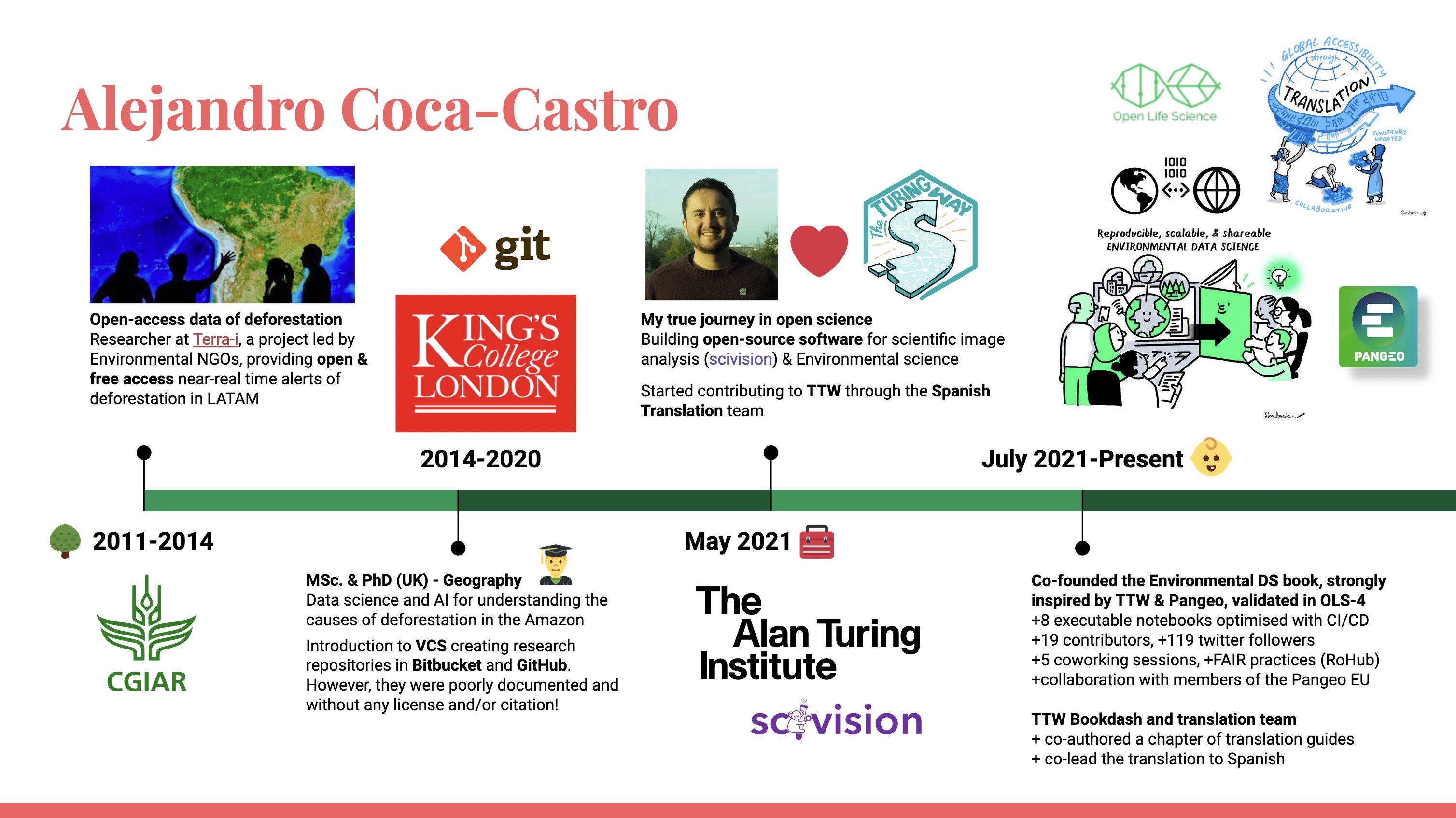
Let’s begin in March 2020, when COVID-19 restrictions started in most countries and coincided with the deadline for submitting my PhD thesis. What’s more, it was the month my sponsor’s scholarship-loan funding came to an end. Without many options, my wife and I decided to leave London and return to Bogota (my home city). Despite every possible pressure, I met my goal of submitting my thesis on 30 March 2020 — a very memorable day! I then defended my thesis remotely in May 2020, celebrating by video call with my family, supervisors and friends. I received my doctorate in Geography from King’s College London in September 2020.
During the period of thesis corrections and job hunting, I was selected for a virtual data-science training programme run by the Colombian government and organised by Correlation One. As part of the programme, together with other participants, we applied what we’d learnt in a project focused on developing models and a data dashboard to predict recidivism in the Colombian penal system (see details here). Later, in August 2020, I joined the Agustín Codazzi Geographic Institute (IGAC) — a Colombian government body known for its role in cartography and land-use planning — as a contractor. During my 5-month contract I had the opportunity to be the technical lead of teams of 5 to 6 researchers and to publish, in scientific journals, the results of two projects involving data-science and artificial-intelligence technologies: one on mapping buildings in rural settings (see details here) and one on digital soil mapping (see details here). I also coordinated a challenge for Correlation One’s data-science programme that sought to develop predictive models from an IGAC soils database (see the repository here).
With my IGAC contract at an end and little success in finding academic positions, I decided to take the entrepreneurial route. Along this path, the lessons I’d received in an extracurricular programme offered by my university’s entrepreneurship institute during my PhD proved valuable. I registered GeoMagic Labs, a geolocation technologies consultancy, with the Bogotá Chamber of Commerce. Through my venture I was selected in a consultancy competition with Solidaridad Network, an NGO focused on facilitating the development of socially responsible, ecologically sound and profitable supply chains. In my proposal I developed a methodology for mapping coffee production systems using openly accessible satellite imagery (see details here).
Stage 4: open science, May 2021 - present
In November 2020, my PhD sponsor’s loan-forgiveness rules changed, opening the door to new opportunities. It was no longer mandatory to demonstrate employment at an institution in Bogota for the length of time I’d received funding (that is, 4 years!). The new rules were flexible about other kinds of outputs, including publishing papers and/or starting a venture related to the PhD topic. Against this new backdrop, I applied for a postdoctoral position at the Alan Turing Institute in the United Kingdom in December 2020. I was already familiar with the Turing environment from a collaborative hackathon I took part back in December 2019 (see the report here). The postdoctoral position matched my profile, and I was drawn to the possibility of learning probabilistic modelling, improving my software development skills and contributing to Pangeo, a community championing open science for big-data analysis in the geosciences.
In February 2021 I was invited to an interview, which included a 5-minute presentation followed by a walkthrough of code I’d written and questions from the interview panel. It was my first postdoc interview, so it was natural to be a little nervous. Nevertheless, I gave solid answers, highlighting my experience collaborating across diverse research groups. When showing my code, I was able to demonstrate how it had been used and visited on Zenodo (a platform for registering digital research objects). A few weeks later I received the offer, starting remotely from May 2021. My wife and I then left our life in Bogotá and decided to restart our life in London at the end of July that same year.
Being part of the Turing, I’ve had the opportunity to collaborate with many researchers in the United Kingdom and their collaboration networks. Below are the projects and initiatives I actively contribute to:
My postdoctoral project consists of developing tools based on the intelligent fusion of environmental sensor data to improve the monitoring of our changing planet (see details here). In collaboration with researchers from the British Antarctic Survey and the Met Office, we’re developing a tool based on probabilistic modelling that combines data of different modalities (gridded data, in-situ stations and auxiliary data) to obtain finer, more local observations of environmental variables. In addition, using greedy algorithms, the tool is designed to suggest where to install local sensors to reduce the uncertainty of the modelled environmental variable. I’m fortunate to contribute my experience to the tool’s development, in my case working with researchers from the UK Centre for Ecology & Hydrology (UKCEH) to model soil moisture.
I’m the founder and lead of the Environmental Data Science Book (see details here).
It’s a resource led by the environmental community where Jupyter notebooks showcase advances in data, methodologies and other kinds of research using open-source tools. Through this initiative I collaborate with other members of the Pangeo community in Europe to further democratise scalable, open-source tools for the geosciences.I’m a member and developer of scivision (see details here), an open-source tool developed by researchers across different domains — including molecular biology, agriculture and the environment — together with professionals from the Turing’s Research Engineering team. My role in the project is to ensure the tool generalises across a variety of imagery (satellite, drone, climate data, and more) and models from the environmental sciences community.
I’m a member and co-lead of the translation team in The Turing Way, a community-led initiative promoting best practices for open and reproducible science (see details here).
Summary
That brings the second instalment of Alejandro 101 to a close. It’s a pleasure to share my professional and academic development, as well as some opportunities for those interested in open environmental science and information technologies.
I’ll take this chance to mention that, if my content proves useful, I’ll be publishing monthly (workload and family life permitting) on a range of topics — from tool discussions (with code) to concepts and frameworks in open science, environmental science and information technologies. From time to time I’ll also share the odd update on my personal life or travels that might be enriching for other readers of this blog.
For an inclusive and transparent science 🚀
- Data Study Group Team. (2020). Data Study Group Final Report: WWF. 10.5281/ZENODO.3878457