Hello world
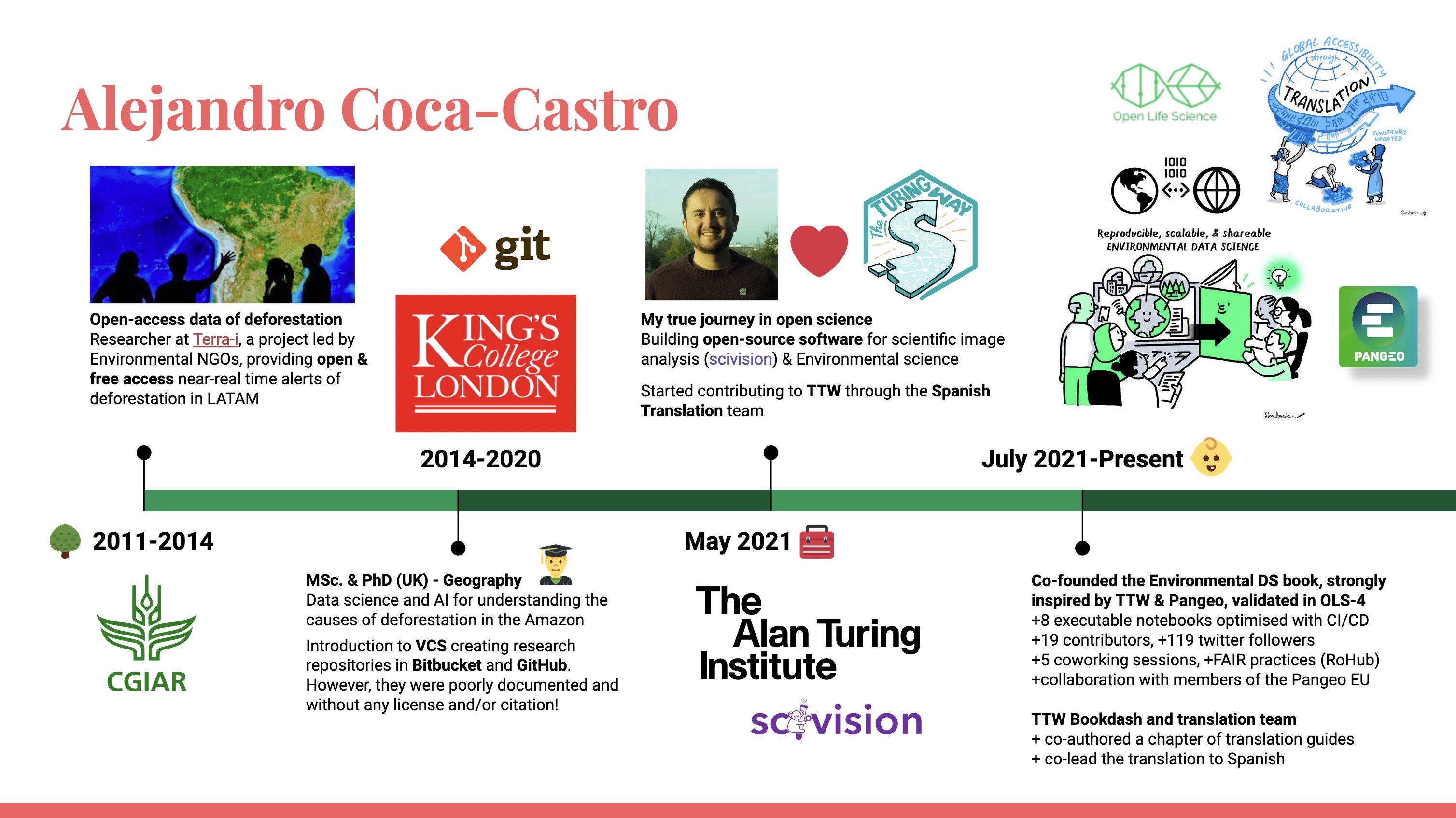
Inspired by the timeline I shared at the fireside chat organised by The Turing Way, the first entry of my blog is a reflection on what my journey over the last 11 years has looked like.
I’ll briefly recount my most relevant experiences in open environmental science and information technologies through a series of anecdotes, organised by stages. These anecdotes go beyond the technical and include opportunities I’m sharing so that others on similar paths can take advantage of them.
Let’s begin!
Stage 0: beginnings, < 2011
Although I couldn’t capture it in my timeline, my first encounters with spatial information technologies came during my undergraduate studies in Agronomic Engineering. I had the opportunity to take modules on spatial models and data as part of the Geomatics postgraduate programme at my alma mater, Universidad Nacional de Colombia. I also went on an exchange to the University of São Paulo, Brazil, where I got to know a new culture and joined research groups using geoprocessing technologies applied to environmental and agricultural studies. During this exchange I trained in several satellite image-processing tools, both closed-license ones such as ERDAS and ENVI and open-license ones such as SPRING. My GIS skills were mainly in ArcGIS, with a little QGIS. Towards the end of my studies, in May 2011, I had the chance to put my knowledge to the test with my first consultancy, producing a database and cartography for a catalogue of medicinal plants in Colombia (see details here).
Stage 1: open deforestation data, 2011-2014
As part of my undergraduate professional placement I joined the Terra-i project at the International Center for Tropical Agriculture (CIAT), now known as the Alliance of Bioversity International and CIAT. This project had a very positive impact on my professional development. Terra-i is an initiative for global habitat-loss monitoring, generating deforestation alerts freely and openly. Given the project’s relevance to the organisation’s agenda, I took part in several sub-projects that used the tool’s data to quantify the state of ecosystems in Latin America and the Caribbean, as well as to forecast the impact of road infrastructure projects in the region (see details here).
As a proactive researcher I represented the project at several international events on conservation, forests and geospatial technologies. I also extensively promoted the use of the open data through case studies on the project blog (see, for example). I authored and coordinated a protocol for field validation of deforestation alerts in the Peruvian Amazon, which was later replicated in other regions. In terms of communities, I was a scholar of the Society for Conservation GIS (SCGIS), a programme funded by ESRI and environmental organisations, which I personally recommend for improving GIS skills and meeting other researchers around the world applying these technologies to conservation.
Stage 2: MSc and PhD in Geography, 2014-2020
Through the Terra-i project I met Mark Mulligan, a professor at King’s College London, with whom — in collaboration with the Terra-i project — we tackled the study of the drivers of deforestation in the Amazon biome. It was a period in which I trained in and applied data science, artificial intelligence and cloud computing. In my MSc I analysed the spatial patterns of deforestation using data mining and fractal analysis (see details here). Using two open deforestation data sources, Terra-i and the Global Forest Change maps, my research managed to map the spatial distribution of patterns associated with different agents of deforestation. In my PhD I took a deeper approach, applying time-series analysis techniques to extract information on land cover and land use following deforestation from satellite imagery (see details here). This research pioneered the use of convolutional recurrent neural networks for classifying MODIS image time series. The models were trained using the Terra-i project’s hardware resources as well as Google cloud-computing credits.
Beyond the technical progress during my studies, I think the most exciting part was maximising collaboration and mobility (exchanges, placements, conferences and research groups). For instance, during my MSc I did a placement at Global Canopy, an environmental NGO based in Oxford, United Kingdom, where I carried out an analysis of water security in the Amazon (see details here). During my PhD I went on exchanges to HEIG-VD in Switzerland and later, in 2019, to CIAT’s regional office in Asia, in Vietnam. At the first institution I trained in Python programming, Big Data and Deep Learning in the lab led by Professor Andres Perez-Uribe, and at the second I refined my analyses and models with my co-supervisor at CIAT, Dr Louis Reymondin. I’d also highlight the internship in the summer of 2018 at the Satellite Applications Catapult on the Harwell Science and Innovation Campus (United Kingdom), where I took part in the Frontier Development Lab (FDL) accelerator. There, alongside other researchers affiliated with European institutions, I worked on mapping informal settlements from medium-resolution imagery such as Sentinel-2 and very-high-resolution imagery such as WorldView-4 (see details here).
Summary
In this first instalment of Alejandro 101 I’ve briefly recounted my experiences from my undergraduate studies through to my PhD. Many different people inspired me, and I was fortunate to collaborate with them throughout those years. It was a period full of professional and personal achievements, with very valuable friendships I still keep, as well as the joy of starting a family during the third year of my PhD.
In the next instalment I’ll continue with the second part of the timeline, from which I believe I’m successfully building new foundations for leadership in open environmental science. I’ll also share opportunities and experiences that may prove interesting!
For an inclusive and transparent science 🚀
- Hansen, M. C., Potapov, P. V., Moore, R., Hancher, M., Turubanova, S. A., Tyukavina, A., Thau, D., Stehman, S. V., Goetz, S. J., Loveland, T. R., Kommareddy, A., Egorov, A., Chini, L., Justice, C. O., & Townshend, J. R. G. (2013). High-Resolution Global Maps of 21st-Century Forest Cover Change. Science, 342(6160), 850–853. 10.1126/science.1244693